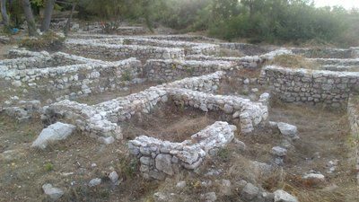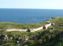


Kraneia city is situated near the village of Kranevo. It is situated on a hill with a flat surface, surrounded by rocks everywhere. Fortress has the shape of a triangle and is the most inaccessible from the east because there is an extremely steep hill and almost vertically from the terrace to the sea.
The city of antiquity and late Middle Ages “Kraneia” is located 1.4 km to the south in a straight line from the center of the Kranevo village. It is located on a hill almost private, with a flat surface, which is 252 m high and has a close relationship in the most south with the rest of the hill range. The hill is surrounded by steep cliffs everywhere in the highest part of the route going fortified wall along its edge. Fortress is the most inaccessible from the east, where the hill is very steep, almost vertical on the large terrace.
The fortress has the shape of a triangle. The east wall is 860 m long around her, without fortification towers because of the inaccessibility of land. Southwest wall is approximately 460 m, and had 17 towers without the corner. Northwest is approximately 630 m long and had 18 towers without corner. The fortress possessed 37-40 towers in total. The wall was built well from treated limestone square face and filled with stones, cemented with mortar. They had a width of 3 m. At present, are seen very little remains of the walls above the surface.
No land excavations were conducted, therefore no detailed information glances related to the form of the towers. It had two gates. One was on the southern wall where a road goes to Kastritsi. The other one was on the northwest wall where a road is leading down to the valley to sub-construction fortress. The northern part of the city was separated by a wall 128 meters long. So it formed a second city, smaller, again with triangular shape, surrounded by some of the north-west (188 m) and part of the east (140 m) to the big city. In the foothills northeast of the hill on the international pioneer camp territory in 1976, there were discovered remains of the city wall that has a width of 2.6 m. and the face is constructed of large stone squares.
Separately, earlier in 1951, it was found a west wall apparently of the same city, with the round tower of the southwest. It was found that the tower in 5-6 century was used as a studio, in wich they made ceramic matrix lamps. It is therefore not used in the early Byzantine period. Here there were medieval buildings, but no information if in the Middle Ages there was a fortress. From the above it can be concluded that the hill south of Kranevo village, the Romans built a well-fortified city under the guard well secured to the sea without a port. Due to the lack of appropriate port suggests that this is not a Greek polis. The City guarded the valley of Batovska, of in the most eastern Roman provinces over the border here and Mizia Two Scythia. During the early Byzantine the fort near sea park it was destroyed and never restored later. During the First Bulgarian state on its territory, Kranevo, was raised a wave of border guarding the coast invasion. In sec. 13-14 the city had city status with unprotected area under the fence.