


Chucklite are groups of stone pyramids formed from Mezdra and Kaylashka chalkstone angled towards the canyon of the river. Ruchene are between the villages Kameno and Reselets. The most beautiful from these groups are named Chuklite in 1974. In the development of the Register and Real Estate Register of the geological phenomenon in the period 2000 – 2003, it was determined the fact that the location of these geotopes it is most certainly wrong on the territory of the plain Kameno. For the protection, it refers to the location “Tselkinskite Chuklite”, meanwhile the real Chuklite are situated at 2 km. East, along the canyon on the neighboring territory, Breste, the region Pleven (43.22373, 23.96612).
From the geological point of view, the area is situated in the northern part of the Western Balkans. In the valley of the river there are developed the superior Cretaceous chalkstone, covered by soil.
The base from the pumping station is situated at 4 km. east from the village in the river canyon. The nodular chalkstones with antique age are discovered 1 – 2 m. of argil sand. They comprise fragments of seashells from Mesozoic. Above them there follows a grey, almost beige layer, healthy, of massive chalkstone with nodules Mezdrensko suite. Their thickness in the canyon of the river is of 70 – 80 m. The superior limits are a fast litho logical transition of chalkstone from the Kaylashka area covering the superior levels of the cut.
In the center of the suite there is a layer of volcanic ash corresponding to the layers of ash which are found in the geological phenomenon Strupanitsa, the station Karlukovo. The microscopic analysis showed a raised content of quartz, unchanged plagioclase, biotyte and crystals of unchanged idiomorphines magnetite. This thing confirms the volcanogenous origin of this layer of ash from the Mezdra basis and the version that in that particular moment the volcanic activity in the adjacent areas of the Mizia platform was still active. Most likely is the fact that the material of ash was transported by the wind from the continuity of the volcanic activity, in the today’s area of the Carpathians.
There were found nanno-fossils Broinsonia parca (Stradner) ssp. constrictaHattner and colab., Petrarhabdus vietus Burnett, Reinhardtites levis Princs & Sissingh, Ceratolithoides aculeus (Stradner) and Uniplanarius trifidus (Stradner), which determined the affiliation with nanno-fossils stones Uniplanarius trifidus with Cretaceous age.
All the rock dolls were developed in Mezdra and only the superior parts of chalkstone arrive in Kaylashka. Common of strati-graphic level, this geological phenomenon are developed of chalkstone with a granulation lower than 1 mm. These are smashed volutes of foraminifere, ostracode, corpusculi calcite and nanoplankton cretos. The rocks with a hard texture are accentuated by the presence of a silex nodules. Obviously is the fact that the nature of this chalkstone texture encourages the development of some similar morphological shape. The fissure of 350 – 450 facilitates, also, the erosion processes on vertical of the escarpments.
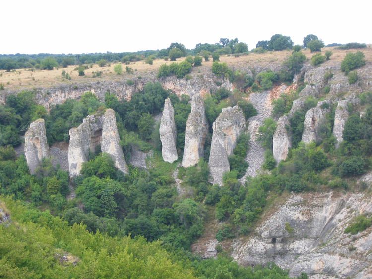
This comprises more groups of rock dolls, at an altitude of approximately 300 m along the picturesque canyon of the river. The canyon distance isn’t equally marked, but its margin has a magnificent view – 90 meters deviation in the lower part towards the small river and the back falls are extremely abrupt and covered with vegetation. The southern versant is a vertical rock, while the northern part is superficial and on it are rock formations. From the west to the they are arranged in the following order: Kraskyovski Chuklite, the Chuklite Butecher and Tselkinski Chuklite in the inferior village and the Chuklite House and two western groups without a name and from the east from them in the village Bresle … In the surrounding area there are three separate protected groups, of which one of them – “The Doll Rock” is, also, a natural canyon. From the geological point of view, the entire area is situated in the north – east part of the anterior part from West, near the border, with the platform Moesica. Among the rocks there stand out Kuninskata, Mezdra and Kaylanska, which are almost horizontal. They are formed in the occidental river of salted sea, at the end of the Mesozoic era in Maastricht and sections of the region the Campaign from the Cretaceous century (66 – 72.000.000 years ago).
Among the morphological shapes of Chuklite there exists a vast diversity, but most of them are oval, elongated or in section, in the shape of a cone and a column. In most of the cases, these are connected by a “collar” with the pant of the defile or one from the other, forming a fan. Their height varies from 12 m to more than 35 m, is in direct connection with the distance of the object from the walls of the canyon. The width at the base of the individual columns of rock or of the cones is of the order of 5 – 6 to 10 m. Rare, but spectacular, as distinct pyramids, resulting in horizontal shapes in the floodable area, there are formed deep horizontal kennels of passing at the same level in all the columns.
The forming of the rock pyramids alongside the river is the specific result of combining the cretaceous superior rocks in the area, the litho logical sensibility predetermined by the stones at karsting and the exploitation of the rain water on the pants of the canyon. The lacking of the vegetation continuously encourages their development.
Despite its high esthetical value, the rock pyramids alongside the river are available only for the pedestrians. They can be reached by the land rivers only on the dried river. The access to the river valley is ensured by the roads conceived to serve for the one from the pumping stations.
In the region there isn’t any conserved tourist infrastructure. The cottage from above the pumping station where it is opened the picturesque image of Chuklite, was destroyed. The distance of the human establishments makes the canyon to be habited for the predatory animals.
Because of its activity, the compacted and the common genesis, the stone pyramids from the canyon of the river between the villages Downtown and Reselets, together with the numerous caves and Karstic rivers developed in the region of the description, they are very adequate in order to melt with in a geo-park destined thematically to the karstic processes. The reason for this is the presence of more groups of geo-morphological entities in no way inferior to the protected sites. In the lower part there are still protected objected, such as the rock dolls and citadel, situated in the citadel park. If you would take into consideration the numerous caves and Karstic fountains, intercalated with the habitat of the big prey birds and of other species of rare animals and plants, the canyon of the river Manual can be considered very beautiful. The geo-park is concentrated upon the Karstic thematically processes and on the shapes.